
Batesville VA Homes For Sale
 $4,000,000
Active
$4,000,000
Active
2098 Goodling Rd North Garden, Virginia
6 Beds 7 Baths 10,773 SqFt 29.6 Acres
 $3,795,000
Active
$3,795,000
Active
7337-4B Dick Woods Rd Afton, Virginia
5 Beds 6 Baths 6,202 SqFt 23 Acres
 $2,475,000
Active
$2,475,000
Active
3 Dick Woods Rd Afton, Virginia
3 Beds 4 Baths 5,246 SqFt 8.45 Acres
 $2,285,000
Active
$2,285,000
Active
4040 Edge Valley Rd North Garden, Virginia
5 Beds 5 Baths 8,271 SqFt 22 Acres
 $1,900,000
Active
$1,900,000
Active
840 Murray Ln Charlottesville, Virginia
4 Beds 4 Baths 7,361 SqFt 21.16 Acres
 $1,895,000
Active
$1,895,000
Active
1141 Kingsway Rd Charlottesville, Virginia
5 Beds 7 Baths 8,292 SqFt 7.08 Acres
 $1,825,000
Active
$1,825,000
Active
4035 Edge Valley Rd North Garden, Virginia
5 Beds 5 Baths 8,271 SqFt 10 Acres
 $1,818,791
Pending
$1,818,791
Pending
TBD Dick Woods Rd Afton, Virginia
4 Beds 4 Baths 5,145 SqFt 8 Acres
 $1,549,000
Active
$1,549,000
Active
7337-B Dick Woods Rd Afton, Virginia
4 Beds 4 Baths 4,016 SqFt 5.63 Acres
Batesville is a quaint, historic village located in Western Albemarle between Greenwood and North Garden.
The village consists of the historic Batesville Market and the post office inside its building.
There are several historic churches nearby, and the home of the private Miller School of Albemarle.
Batesville, VA homes for sale are popular and if priced correctly, sell quickly.
The majority of Batesville homes are historic.
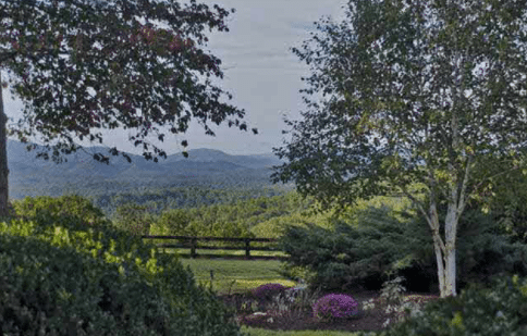
Surrounding the small village are numerous spectacular Charlottesville farms.
Batesville, VA Real Estate for Sale: A Comprehensive Guide to Luxury Living in Western Albemarle
Hello, folks! I’m Toby Beavers, one of the best Charlottesville real estate agents with experience navigating the ins and outs of homes for sale in Albemarle County, VA, since 2003.
Today, I’m excited to take you on a deep dive into Batesville, VA real estate, a charming, historic village in Western Albemarle County that’s become a haven for luxury homebuyers seeking a blend of rural serenity and modern sophistication.
Whether you’re searching for Batesville, Virginia homes for sale, curious about Batesville homes for sale, or just exploring the idea of owning one of the stunning Batesville homes, this guide will give you the full scoop.
As a seasoned realtor who’s sold properties from downtown Charlottesville to the rolling hills of Albemarle, I’ll share my insights on why Batesville, VA homes for sale are so special, what’s available in 2026, and how you can find your perfect piece of this picturesque paradise.
Where Is Batesville, Virginia, and What’s the Draw?
Batesville, VA, sits in the southwestern corner of Albemarle County, about 15 miles west of Charlottesville and just north of North Garden.
It’s not a bustling town with a downtown strip; think of it more as a quaint, unincorporated village where history and nature take center stage.
Nestled in the shadow of the Blue Ridge Mountains, Batesville offers a peaceful escape along Route 151, a scenic corridor known as Virginia’s wine country.
For anyone eyeing homes for sale in Batesville, VA, it’s the kind of place where you can hear the crickets at night and still be 20 minutes from UVA or Charlottesville’s vibrant dining scene.
The drive into Batesville is pure Virginia magic, rolling hills, mature hardwoods, and glimpses of mountain vistas that make every trip feel like a getaway.
Over my 23 years as a Charlottesville realtor, I’ve watched Batesville transform from a quiet agricultural hub into a sought-after spot for luxury estates and historic homes, all while keeping its small-town soul.
Numerous vineyards have been built Loving Cup Vineyard & Winery, Pippin Hill Farm, Mountain & Vine Vineyards, and Albemarle Cider Works.
The fabulous farming development, Bundoran Farm, was finally developed.
With a population hovering around a few hundred, it’s a tight-knit community where neighbors know each other, and the pace of life feels refreshingly slow.

The Charm of Batesville, VA Real Estate
So, what sets Batesville, Virginia homes for sale apart?
It’s all about the lifestyle they offer, space, privacy, and a deep connection to Virginia’s past.
Unlike the tighter lots you’ll find in suburban Charlottesville, Batesville homes typically sit on generous parcels, ranging from a couple of acres to over 100.
This is country living at its finest, perfect for folks who want room for gardens, horses, or just a big lawn to enjoy.
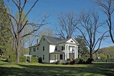
Batesville properties here are a mix of meticulously restored historic homes and newer custom builds that nod to traditional Virginia architecture, making Batesville, VA, real estate a treasure trove for buyers with an eye for character.
Take a property that sold in 2025 at 6742 Plank Road, a stunning 3-bedroom, 3-bath antebellum home from 1780-1820, restored to perfection with 9 fireplaces, heart pine floors, and a copper roof, all on 3.55 acres for $2.1 million.
Or consider a 66.75-acre parcel at 0 Midway Road, which was recently listed at $1.85 million, a blank canvas with mountain views and four division rights, ideal for a family compound or vineyard.
These aren’t just houses; they’re legacies.
Batesville homes for sale appeal to buyers who want more than a roof over their heads; they want a story, a retreat, and a slice of paradise.
Batesville, VA Homes Offer Rich History
Batesville’s roots run deep, and as a Batesville, Virginia, realtor who’s spent two decades digging into local lore, I can tell you it’s a big part of its allure.
Founded in the late 18th century as a stagecoach stop and agricultural center, the village still echoes its past through landmarks like the Batesville Historic District, listed on the National Register of Historic Places.
The Batesville Market, a community hub since 1900, sits at the corner of Plank Road and Craig’s Store Road, offering gourmet food, live music on weekends, and a taste of local life.
Nearby, historic churches and homes like Bellevue (aka Wavertree Hall) add to the village’s timeless charm.
Samuel Miller, one of America’s richest men when he died in 1869, called Batesville home and left a legacy with the Miller School of Manual Labor, a school for the poor to learn a trade. Today, it’s the Miller School of Albemarle, a day and boarding school on Miller’s original 1,600-acre estate.
That history infuses Batesville, VA, real estate with a sense of permanence; buying here means owning a piece of Virginia’s story.
I’ve had clients fall in love with homes for sale in Batesville, VA, just for the tales their walls could tell, from colonial craftsmanship to modern updates that honor the past.
Batesville, VA Homes: Architectural Styles and Features
When you browse Batesville homes for sale, you’ll find a delightful mix of styles.
Batesville, VA historic homes, like that Plank Road gem, boast period details: wide-plank floors, custom moldings, and fireplaces galore, often paired with modern upgrades like high-speed internet, gourmet kitchens, and whole-house generators.
Newer builds, meanwhile, might feature open-concept designs, walls of glass to frame mountain views, or eco-friendly touches like solar panels.
I recently toured a contemporary 4-bedroom on 40+ acres near Mechums River, complete with a renovated guest house and expansive deck, listed at around $1.5 million.
It’s a perfect example of how Batesville homes blend luxury with the landscape.
Batesville Village lot sizes are a huge draw.
Even smaller properties start at 2-3 acres, while estates can sprawl across 50 or more, often with streams, ponds, or pastureland.
Outdoor features shine too, think wraparound porches, stone patios, or barns for equestrian enthusiasts.
Inside, expect high-end finishes: soapstone countertops, cherry cabinetry, or spa-like bathrooms with Roman showers.
Whether you’re after a historic charmer or a modern masterpiece, Batesville, VA, real estate delivers properties that feel both timeless and tailored to today’s comforts.
The Batesville Real Estate Market in 2026
Let’s get down to brass tacks, numbers matter, and I’ve got 23 years of market savvy to share.
As of Spring, 2026, Batesville, Virginia homes for sale range from about $600,000 for a modest 3-bedroom to over $12 million for luxury estates.
The median price sits around $1.47 million, based on recent listings, though that’s skewed by the mix of smaller homes and multi-million dollar properties.
Luxury buyers, my bread and butter, often target Batesville homes between $1 million and $3 million, especially those with acreage or historic appeal.
Inventory is always slim, folks.
With only a handful of Batesville homes for sale at any time, say, 1 to 7, depending on the season, competition can heat up fast.
A 3-bedroom historic home on 3.55 acres at 6742 Plank Road, listed at $2.1 million, lingered for 167 days, but that’s an outlier; most move quicker, averaging 60-90 days on market.
Prices have climbed about 5% annually, driven by demand for rural luxury and Albemarle County’s appeal.
Sellers are in a strong position; Batesville real estate often fetches close to the asking price, while buyers need to act decisively.
I’ve got a knack for finding off-market Batesville, VA real estate, so if you’re serious, I can dig up options before they hit the MLS.
At the high end, 6742 Plank Road offers that 4,284-square-foot antebellum beauty on 3.55 acres, 3 bedrooms, 3 baths, and a 3-bay barn with a copper roof, sold for $2.1 million.
It’s a restored masterpiece with creek frontage and mountain views, perfect for history buffs or luxury seekers.
On the land side, 0 Midway Road’s 66.75 acres at $1.85 million was a developer’s dream, with gently rolling hills, hardwood groves, and two streams, with four division rights for a compound or vineyard.
Closer to $500,000, you might find a 3-bedroom ranch on 2 acres needing some TLC, think fixer-upper potential in the Miller School district.
I’ve also got my eye on a 47-acre parcel near Greenwood with mountain vistas and pastureland, hovering around $1.6 million, ideal for a custom build.
Inventory shifts fast in Batesville, so if you’re browsing homes for sale in Batesville, VA, I can set you up with real-time alerts or uncover hidden gems.
Just give me a shout!
Lifestyle: Living in Batesville VA
Living in Batesville is like stepping into a postcard: quiet, safe, and surrounded by nature.
Crime’s negligible, and the community’s small, about 71% of homes are owner-occupied, with a mix of retirees, professionals, and families.
The Western Albemarle school district (Murray Elementary, Henley Middle, and Western Albemarle High) is a big draw, with top-notch academics and a rural setting.
I’ve sold Batesville homes to UVA faculty who love the 20-minute commute and retirees who spend their days hiking or sipping wine at nearby Pippin Hill Vineyard.
Outdoor living’s the name of the game here.
You’re minutes from Shenandoah National Park, Skyline Drive, and Wintergreen Resort for skiing or golf.
Route 151’s wine trail, think Cardinal Point, Stinson Vineyards, and Lovingston Winery, is right at your doorstep, and the Batesville Market’s live music and gourmet eats keep things lively.
It’s a place where you can fish in your backyard stream, ride horses across your land, or just soak in Blue Ridge views from your balcony.
Batesville to Charlottesville Distance – Proximity and Practical Considerations
Location’s a goldmine for Batesville, VA real estate.
You’re 20 minutes from Charlottesville-Albemarle Airport, 25 from UVA Hospital, and an hour from Richmond.
I-64’s nearby for longer trips, but the daily drive along Plank Road or Route 151 is pure joy; those vistas never get old.
Batesville, Virginia’s classic Virginia: warm summers (86°F highs), crisp winters (20s lows), and fall foliage that’s a showstopper.
Cost of living is higher than the national average, thanks to housing.
A $1.37 million median home needs an income of about $252,000 annually with 25% down, assuming a 35% debt-to-income ratio.
The 2026 Albemarle Real Estate Tax Rate is $0.894 per hundred of assessed value, and utilities align with regional norms.
It’s an investment, but the lifestyle and appreciation potential make Batesville homes worth every penny.
Why Purchasing Batesville, VA Real Estate is a Smart Move
After being in the Albemarle County homes for sale since 2003, I can tell you, Batesville, Virginia homes for sale are a golden opportunity in 2026.
Demand’s strong, folks want space and nature post-pandemic, and supply’s limited, pushing values up.
Whether you’re after a historic estate, a modern retreat, or raw land to build your dream, Batesville, VA, real estate offers unmatched appeal.
Sellers, list now, you’ll likely see quick offers, especially if your home’s polished and priced right.
Buyers, timing’s key, move fast on Batesville homes for sale, or let me tap my network for off-market deals.
The village’s blend of history, natural beauty, and proximity to Charlottesville checks all the boxes for luxury living.
I’ve seen firsthand how Batesville transforms lives.
It’s not just a home, it’s a legacy, a retreat, and a connection to Virginia’s soul.
Finding Your Batesville Home with Toby Beavers
So, is Batesville right for you? If you crave privacy, history, and a touch of luxury in a rural setting, absolutely.
It’s not for city slickers or bargain hunters, it’s for folks who want a home that’s as unique as they are.
I’ve helped countless clients settle into Batesville homes over the years, from young families to retirees, and each one has found their perfect fit.
Ready to explore homes for sale in Batesville, VA?
Whether you’re browsing listings online or want a boots-on-the-ground tour, I’m your guy.
Being a top Charlottesville real estate agent since 2003, I’ve got the local knowledge, market insight, and passion to match you with a Batesville property you’ll love.
Call me today, and let’s find your dream home in this historic village, because in Batesville, home isn’t just a place; it’s a way of life.
Toby Beavers, a top Albemarle VA, realtor since 2003, may be reached by phone or text at 434-327-2999